AGERE INTEGRITY VALVE SPACING RELEASE
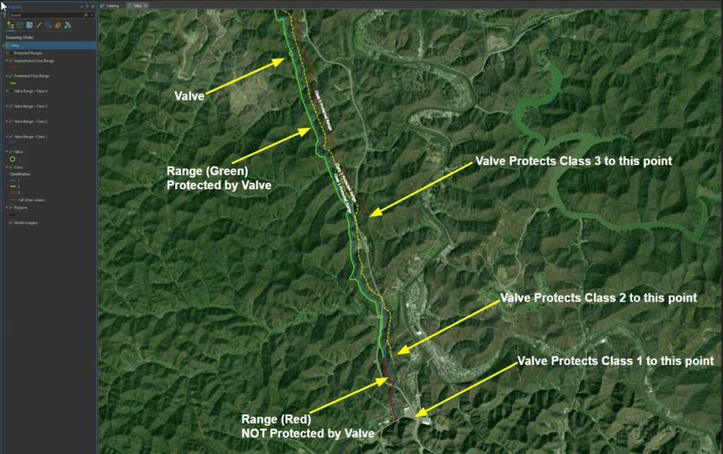
Agere Integrity has released a new build of the application available for ArcGIS Pro 3x and ArcGIS Enterprise 11x. This new release provides clients with a module to run valve spacing analysis for Class Location results with configurable settings for spacing distances and data source. During the analysis, valves are buffered to determine the upstream […]
AGERE INTEGRITY ENHANCEMENT RELEASE
Agere Integrity will be releasing a new build of the application available for ArcGIS Pro 3x and ArcGIS Enterprise 11x. This new release will provide clients with improvements to Class Location clustering calculations, MCA analysis, and the desktop user interface. The enhancement for clustering provides settings to establish buffer distances between structures in clusters for […]
Agere Integrity Joins PODS Community
Agere Integrity, an integrity management application suite for pipeline operators, announced they havejoined the PODS (Pipeline Open Data Standards) Association, a member-driven group that manages adata model standard used by pipeline operators, service providers, vendors, and regulatory agencies formanaging spatial data for pipeline data. Agere Integrity is compatible with all versions of the PODS data […]
Agere Integrity Launches Support for ArcGIS Pro 3.0
Agere Integrity is now compatible with ArcGIS Pro 3.x, providing pipeline management industry operators with software to manage their systems on the latest Esri technology! The application’s new release comprises an extension that runs on ArcGIS Pro 3.x versions. Users can now take advantage of new functionality, including an enhanced ArcGIS Pro launch experience, map […]
Agere Integrity Launches Application Functionality for Integrity Management to Support Gathering Rules
Agere Integrity launched the second module of the Agere Integrity Suite of applications for pipeline operators in March 2022. The application enhancements will allow operators to perform Class Location Analysis on Gathering lines. The functionality to calculate Class Location Analysis in accordance with the PHMSA rule changes released in 2021. Highlights of the new functionality […]
Agere Integrity Partner with Esri to Provide Pipeline Integrity Management Software Based on Esri’s Latest Technology
Agere Integrity Joins Esri Startup Program
Agere Integrity Launches Application for Integrity Analysis on Esri’s Latest Technology
Agere Integrity launched the first module of the Agere Integrity Suite of applications for pipeline operators in January 2021. The application will allow operators to perform High Consequence Area (HCA) and Class Location Analysis on the latest Esri software. It is comprised of an extension to ArcGIS Pro and processing components in your ArcGIS Enterprise […]